Explore our GIS Data Generation
GIS Data Generation
- Geo-referencing of scan information into AutoCAD® drawing
- Collecting of topological elements using specific layers
- Store information by using Object Data Table and Extended Data
- Assembling cadastral map sections into one big map
- Export AutoCAD® model into a GIS medium: ESRI, Intergraph, MapInfo, SmallWorld, etc.
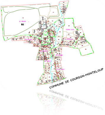
Samples of our Work:

We're ready to help!
Ready to discuss CAD & GIS project? We are here to help! Send us an email and we’ll get in touch shortly, or phone between 8:00 and 18:00 Monday to Friday — we would be delighted to speak.
Your details are kept strictly confidential as per our Privacy Policy.
Trusted by: